

Many UK franchise hopefuls assume territory boundaries are drawn almost at random, perhaps based on rough county lines or a franchisor’s gut feeling. The reality is far more rigorous and, frankly, more fascinating. Territory mapping is a data-driven discipline that directly shapes how much money you can make, how many customers you can reach, and whether your franchise will still be viable in five years. Understanding it before you sign anything could be one of the smartest moves you make.
Key Takeaways
| Point | Details |
|---|---|
| Data-driven mapping matters | Smart territory mapping in UK franchising relies on data for fairness and profit. |
| Types influence your growth | Exclusive or hybrid mapping affects your competition and expansion options. |
| Evaluate mapping regularly | Annual reviews of boundaries help franchisees adapt to shifting UK markets. |
| Prime selection is strategic | Early research and selection gives new franchisees a better chance at prime locations. |
What is franchise territory mapping?
Franchise territory mapping is a subject surrounded by more confusion than it deserves. Strip it back and the principle is straightforward. As defined by industry experts, franchise territory mapping is the process of dividing geographic regions into exclusive or non-exclusive territories for franchisees to operate, using data like demographics, population density, and competition to ensure profitability and fairness.
For you as a prospective franchisee in the UK, that definition carries enormous practical weight. Your mapped territory determines your customer base, your growth ceiling, and your protection from rival franchisees within the same brand. Get a well-mapped territory and you have a genuine business asset. Get a poorly mapped one and you could be fighting for customers from day one.
“Territory mapping is not simply drawing lines on a map. It is a strategic process that blends local market intelligence with national data to create commercially viable units for each franchisee.”
The key data sources used in UK franchise mapping include:
- Population density and demographics: Age profiles, household income, and family size all influence which services or products will sell well in a given area.
- Postcode boundaries: Royal Mail postcode data gives UK franchisors precise, recognisable geographic units that are easy to define in contracts.
- Competition analysis: Both internal competition (other franchisees in the same brand) and external competition (rival businesses) are factored in.
- Footfall and transport links: For retail or food franchises particularly, pedestrian and vehicle traffic data is central to territory value.
- Socio-economic classifications: Systems like Acorn (developed by CACI) categorise UK postcodes by lifestyle and spending behaviour.
Understanding your territory rights in the UK before committing to any franchise agreement is non-negotiable. A territory that looks generous on paper may be economically thin once the underlying data is examined.
Types of franchise territories and mapping methods
Once you understand what territory mapping is, the next question is which type of territory you are actually being offered. The answer matters more than most new franchisees realise.
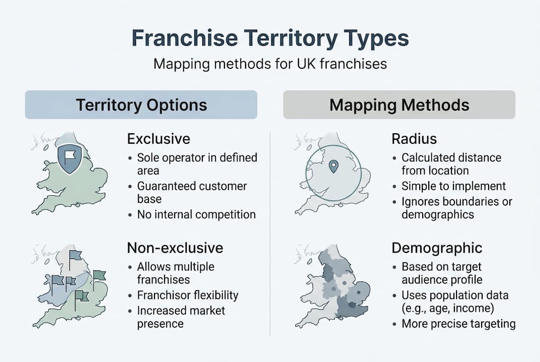
Territory types vary considerably: exclusive territories prevent any same-brand competition within your area, non-exclusive territories allow multiple franchisees to operate in the same geography, hybrid models blend the two, and overlapping territories can be structured for different customer markets within the same postcode. UK franchisors frequently use local authority boundaries and socio-economic statistics to define these zones.
Here is a straightforward comparison of the main territory types and mapping methodologies you will encounter:
| Territory or method | What it means | Best for | Key risk |
|---|---|---|---|
| Exclusive territory | Only you can trade under the brand in your area | Franchisees wanting protection | Limits network density |
| Non-exclusive territory | Others can trade in the same area | Franchisors scaling fast | Internal competition |
| Hybrid territory | Core exclusive zone plus a broader non-protected area | Balanced growth models | Boundary ambiguity |
| Radius mapping | Fixed distance circle from a central point | Simple, fast allocation | Ignores roads and geography |
| Drive-time mapping | Area reachable within a set drive time | Service-based franchises | Data-intensive to set up |
| Demographic-based mapping | Boundaries drawn by population profile, not distance | High-value consumer services | Irregular shaped zones |
Each method has genuine trade-offs. Radius mapping is simple and easy to understand, but a five-mile radius in rural Cumbria covers a very different population to a five-mile radius in central Birmingham. Drive-time mapping is more realistic for service businesses where your team travels to customers, but it requires more sophisticated software to model accurately.
Demographic-based mapping is increasingly popular among premium UK franchise brands because it aligns territory value with spending power rather than raw geography. A compact postcode in a wealthy suburb of Bristol can be worth far more commercially than a sprawling rural territory in terms of potential revenue.
Pro Tip: Before you sign any franchise agreement, ask the franchisor exactly which mapping methodology they use, whether your territory boundaries are written into the contract, and whether the exclusivity clause prevents online or telephone sales from outside franchisees into your area. When negotiating franchise terms, territory clarity is one of the most important points to resolve before exchange. You can also browse franchises by industry to compare how different sectors handle territory allocation.
How mapping shapes franchise opportunities in the UK
Theory is one thing. What really drives understanding is seeing how territory mapping plays out in real UK franchise operations.
Take Chopstix, the fast-growing noodle chain. Their franchise expansion strategy is built on serious data infrastructure. Using the CACI dashboard, Chopstix applied geodemographic profiling through Acorn classifications, combined footfall data, competitor proximity, and turnover potential to rank prospective territories. The result was a prioritised pipeline of franchise locations ranked by predicted commercial performance, enabling the brand to plan its growth towards 100 outlets with measurable confidence rather than guesswork.
That kind of rigour is increasingly the standard for ambitious UK franchise brands, not the exception. The days of a franchisor glancing at a road atlas and drawing circles with a compass are gone.
For a very different type of franchise, consider Football Fun Factory. With over 100 franchisees operating across the UK, the brand uses Smappen to map venues, schools, and community spaces within multi-venue territories. Each franchisee is allocated a geographic zone rich enough in venues to build a sustainable timetable of sessions. Activ Marketing provides business ecosystem analysis alongside this. The mapping is not just about protecting one franchisee from another; it is about making sure each territory contains the physical infrastructure the business model needs to function.
These two examples illustrate something important: the right mapping approach depends entirely on the business model. Here is what a typical territory mapping process might look like from a franchisee’s perspective:
- Initial data pull: The franchisor or a specialist consultant gathers population, demographic, and competitor data for the target region.
- Boundary definition: Provisional territory boundaries are drawn using postcodes, drive-time zones, or demographic clusters.
- Commercial modelling: Projected turnover is calculated based on population size, spending profiles, and market penetration assumptions.
- Franchisee review: The prospective franchisee is shown the proposed territory and invited to review the data and boundaries.
- Negotiation and adjustment: Boundaries may be refined based on franchisee feedback or local knowledge before the agreement is signed.
- Contract inclusion: The agreed territory is written formally into the franchise agreement with clear exclusivity terms.
- Ongoing review: Territories are reassessed periodically as demographics shift and the network expands.
Territory quality is not static. A town growing rapidly due to new housing development may become far more valuable over five years. A retail-dependent territory may weaken if a large shopping centre closes. Reviewing opportunities by county helps you compare mapped territories across regions and spot where population growth trends favour your chosen sector. It is also worth studying franchise marketing strategies for your target sector, because even a well-mapped territory requires active local marketing to convert potential into revenue.
Pitfalls, edge cases, and best practices
Even the most sophisticated mapping process can produce problematic territories. Knowing the common failure modes helps you interrogate what you are being offered rather than accepting it at face value.
The most frequent mistakes in territory mapping include:
- Oversized territories: A territory that looks generous may contain large uninhabitable or commercially irrelevant areas such as moorland, industrial zones, or water. Check population concentration, not just overall size.
- Infrequent updates: Demographic data from five years ago may be dangerously out of date in areas experiencing rapid housing development, migration changes, or economic shifts.
- Ignoring drive times: A territory defined by a simple radius can include areas that take 45 minutes to reach by road, effectively removing them from practical operation.
- Cannibalism risk: In fast-growing networks, franchisees can find the franchisor introducing new units close to their borders, gradually eroding their customer base.
- Gaps in coverage: Poorly planned mapping can leave commercially valuable areas unassigned, creating confusion about which franchisee should serve customers in those zones.
Urban versus rural mapping represents one of the most significant edge cases in UK franchising. Urban territories are typically smaller but denser, while rural ones must be far larger to encompass equivalent populations. The need for regular updates is consistent across both settings because demographic shifts, new developments, and competitive changes alter the landscape continuously. Ignoring these shifts risks both cannibalism between franchisees and gaps where customers are served by no one.
Useful benchmarks for territory sizing show that urban areas typically require a one to two mile radius or around 50,000 people within two square miles, suburban areas need three to five miles, and rural territories may require ten or more miles to capture equivalent commercial populations. Critically, territories should be balanced by revenue potential rather than physical size alone.
“A well-designed territory is not the largest territory. It is the territory most precisely calibrated to support a franchisee’s revenue targets and operational capacity.”
Pro Tip: Ask any franchisor to show you the specific metrics used to calculate your territory’s revenue potential. Request the raw data, not just a summary map. Also push for written confirmation of how frequently territory boundaries are reviewed and what process exists for raising concerns. You can explore franchise management technology to understand what tools franchisors use to maintain territory data, and use guides on how to research franchise opportunities to frame your due diligence questions effectively. For franchises with multiple physical locations, ensuring your multi-location web presence reflects your mapped territory accurately is an often overlooked but genuinely practical consideration.
Beyond the map: what most aspiring UK franchisees overlook
Here is something that most territory mapping articles will not tell you. The map you receive on day one is not the map you will live with for the duration of your franchise agreement. Demographics shift. New housing estates appear. Competitors move in. Consumer behaviour changes. The franchisee who treats their territory as a fixed asset is making a strategic error.
Expert consensus is clear that territories are not just maps but business decisions, requiring a balance between equity and scalability, regular incorporation of franchisee feedback, pilot testing of new boundaries, and annual reviews as standard practice. Yet the majority of prospective franchisees we see exploring opportunities for the first time ask very few questions about how territory data is maintained after the agreement is signed.
The franchisees who thrive over the long term tend to be the ones who stay actively engaged with their territory data. They attend network meetings and flag when competitor activity intensifies near their boundaries. They push for renegotiation when significant housing development alters their population profile. They understand that early territory selection is an advantage, but adaptability is what sustains it.
There is also a subtler point worth considering. A franchisor who maintains rigorous mapping data and welcomes franchisee input on territory performance is signalling something important about their overall culture. It suggests a network that treats franchisees as business partners rather than simply revenue sources. Conversely, a franchisor who is vague about mapping methodology or resistant to answering detailed questions about territory data is worth approaching with caution. The quality of the territory conversation before you sign tells you a great deal about the quality of support you will receive after.
Ask experienced UK franchise operators what they wish they had known before buying in, and territory questions consistently feature near the top of the list. Not just “is my territory exclusive?” but “what does the data say about my territory’s ceiling?” and “what happens to my territory if the network grows significantly around me?” Those are the questions that separate confident, informed franchisees from those who discover uncomfortable surprises eighteen months into their agreement.
Find your ideal franchise territory in the UK
Understanding franchise territory mapping is a genuine competitive advantage when you enter conversations with franchisors. You will ask sharper questions, scrutinise the data more effectively, and spot red flags that less-informed candidates miss. The next step is putting that knowledge to work by exploring real opportunities.
At Franchise Local, we have built one of the most detailed and accessible UK franchise directories available. Whether you are just starting to explore the landscape or ready to compare specific opportunities, our franchise guide for beginners offers a structured entry point that covers everything from investment levels to operational models. When you are ready to compare mapped territories in specific parts of the country, browse franchises by region to see what is currently available near you and identify which brands are actively seeking franchisees in your target geography.
Frequently asked questions
How does territory exclusivity work in UK franchising?
Exclusive territories protect franchisees from internal competition within their brand in a set geography, often defined using postcodes or council boundaries. The specific terms of exclusivity should always be written into your franchise agreement rather than assumed.
How often should franchise territories be remapped?
Best practice is annual review to reflect demographic changes, new competition, and network growth. Regular updates are essential to avoid overlap between franchisees or gaps where customers are not being served by anyone in the network.
What tools do UK franchisors use for territory mapping?
They use GIS data, postcode software, and specialist business analytics platforms. The CACI dashboard with Acorn geodemographics is used by brands like Chopstix, while Smappen supports mapping for service-based franchises like Football Fun Factory that need to account for venues and schools rather than just population.
What happens if a territory is too large or too small?
Territories balanced by revenue potential rather than size perform best. Oversized territories can limit network expansion and leave commercial gaps, while undersized ones risk insufficient customer volume and internal competition that reduces profitability for all parties involved.